Popular Examples
- Resumes
- Cover Letters
- CVs
- Idioms
- Excel Templates
- Business Examples
- Business Letters
- Love Letters
- Personal Letters
- Science
- Math Examples
More IT
- Example of Computer Hardware
- Example of Entity Relationship Diagram
- Example of Game Theory
- Example of GIS
- Example of GIS Application
- Example of GMP
- Example of GUI
- Example of GZIP
- Example of If Else Statement
- Example of PDF
- Example of Pseudocode
- Example of Shareware
- Example of WAN
- Example of WCF
- Example of Wget
- Example of White Paper
- Example of Wiki
- Example of WML
- Example of WPA Key
- Example of WPF
- Example of WSDL
- Example of WYSIWYG
- Example of Xargs
- Example of Xbox Live Code
Example of GIS Application
A GIS application is a product or service, software based, using a GIS system. The best known GIS application is the Global Positioning System, used by practically everyone on Earth as a quick, reliable navigation tool. Other applications use a GIS system for specific purposes, usually based on a major GIS system but adapted to provide a service for personal or commercial use. These systems are evolving as advanced commercial tools, providing consumer information as well as geographic location data. Applications can also provide combinations of data sets like hybrid maps, including ranges of selected data on one map. |
Examples of GIS Applications:
|
Google Earth Google Street View Hybrid online maps https://en.wikipedia.org/wiki/Geographic_information_system#Applications https://gecensus.stanford.edu/gcensus/index.html |
Image Example of GIS Applications:
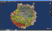 Capaware rc1 0.1. |
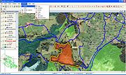 GvSIG 1.0 |
|