Popular Examples
- Resumes
- Cover Letters
- CVs
- Idioms
- Excel Templates
- Business Examples
- Business Letters
- Love Letters
- Personal Letters
- Science
- Math Examples
More IT
- Example of Computer Hardware
- Example of Entity Relationship Diagram
- Example of Game Theory
- Example of GIS
- Example of GIS Application
- Example of GMP
- Example of GUI
- Example of GZIP
- Example of If Else Statement
- Example of PDF
- Example of Pseudocode
- Example of Shareware
- Example of WAN
- Example of WCF
- Example of Wget
- Example of White Paper
- Example of Wiki
- Example of WML
- Example of WPA Key
- Example of WPF
- Example of WSDL
- Example of WYSIWYG
- Example of Xargs
- Example of Xbox Live Code
Example of GIS
GIS is an acronym for Geographic Information System. This is not the same as the Global Positioning System, which is derived from it. The GIS refers to the entire information system, including the networks, hardware, people, and related software and applications that make up the GIS. The system is based on land and mapping data derived from satellite data, topographic systems, surveys, and related mapping software. On this framework, systems like the GPS are created as an overlay on the fundamental data. Street directories, for example, are charted in relation to GIS system data. |
Examples of GIS:
|
These are some of the typical uses of a GIS system: Environmental mappingScientific analysis of regional or global data Archaeology Crime research Zoological research Seismology monitoring Oceanic research https://en.wikipedia.org/wiki/Geographic_information_system https://www-sul.stanford.edu/depts/gis/ https://www.gis.psu.edu/ https://libraries.mit.edu/gis/ |
Image Example of GIS:
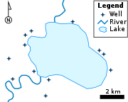 A simple vector map, using each of the vector elements: points for wells, lines for rivers, and a polygon for the lake. |
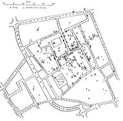 E. W. Gilbert's version (1958) of john snow's 1855 map of the soho cholera outbreak showing the clusters of cholera cases in the london epidemic of 1854. |
|